
Country walks near London
Eight hiking trails on London's doorstep, with pdf guides
About-Britain.com
- a thematic guide to Britain
- Discover Britain
- Essential
information
- Accidents and emergencies
- Pounds and pennies
- Hotel search
- Budget tourism - Britain on the cheap
- Online shopping from the UK
- Driving in Britain
- Low-cost car-hire
- Travel by train in Britain
- Visitor accommodation
- Hotels in London
- Britain's main attractions
- Food and eating in Britain
- Christmas in Britain
- English pubs
- Places
to visit
- Britain's main attractions
- Visiting London
- London for free
- Getting round in London
- Shopping in London
- More great English cities
- Oxford and Cambridge
- Tourism by region
- Discover southeast England
- Discover central southern England
- The West of England - Gloucestershire to Dorset
- The Westcountry - Devon and Cornwall
- Sites & heritage in the East of England
- About Scotland
- Attractions by theme
- Issues & institutions
How to get out of London for a day's walking in the country - in less than an hour by train.
Night
outside London ?
Hotels,
apartments and other accommodation at best rates
from Booking.com
:

Chilterns
:
Box Hill
Marlow
Henley
Staying or living in London, and wanting a day out or a weekend in the country, but don't know where to go? If so, you've reached the right spot.
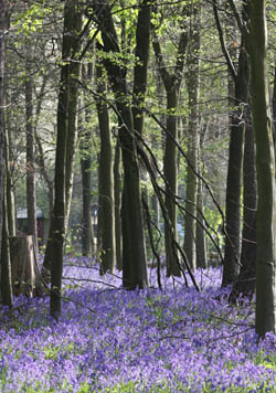
Bluebell woods in the Chiltern hills in spring
For each walk you will find a description of the options available, and information on what train to take, from which London terminus. Each of these walks is directly accessible on foot from the station, with minimal or no walking through suburban streets, before you are really in the country and onto a marked hiking trail. The PDF maps and brief guides can be downloaded and printed, usually on a single page.
Proper hiking shoes or boots are recommended for all these walks, except for the shortest ones, in dry weather.
► Check train times and best ticket prices on The Trainline
| Walk | Location, length | Brief description and rail access information |
| Ashridge and Ivinghoe Beacon |
Hertfordshire,
Chiltern hills, near Berkham- stead. 9 miles. 3 - 4 hours. Plenty of shorter or longer options |
The
Ashridge and Ivinghoe beacon walk
is a 9 mile circular walk, taking in several fine
viewpoints, notably
Ivinghoe Beacon. It includes three miles of the Ridgeway trail, and a
mile or so on the Icknield Way trail, and is for much of the way on the
National Trust land of Ashridge Estate. There is an NT shop and food
outlet . Beautiful
bluebell woods in the spring. The 9 mile walk on the printable map can
be easily lengthened or shortened, as there are many tracks and trails
through Ashridge estate. Walk description and
map here
(pdf format)
Rail
access : Tring station -
36 minutes from London Euston. Ridgeway footpath starts 300 m
from the station |
| Saunderton to Chinnor | Buckinghamshire,
Chiltern Hills. 8 to 10 miles 3 - 4 hours |
The
Saunderton circular walk is a 10 mile circular trail starting and
finishing at Saunderton railway station, just after High Wycombe. The
trail goes as far as the Chinnor Hill nature reserve, on the western
scarp of the Chilterns. Saunderton station is in the middle of the
countryside. There are lots of hiking trails in this part of the
country, so the walk can be extended or shortened according
to
circumstances. Walk description and
map here
(pdf format)
Rail
access : Saunderton
station - 40 to 55
minutes from London Marylebone station. |
| Chorleywood and Chess valley | Hertfordshire 5.7 to 6.6 miles, or more 2 - 3 hours |
The
Chess valley is a beautiful valley in the Chiltern hills, running
northwards from Rickmansworth. It has a number of hiking trails, and
these can be accessed easily, through countryside and parkland, from
the station at Chorleywood. The circuit proposed takes in a part of the
Chiltern Way trail, and is all rural, apart from the last mile which
takes walkers along residential roads in the very leafy town of
Chorleywood. Walk description and
map here
(pdf format)
Rail
access : Chorleywood
station
- 27 minutes from London Marylebone station. |
| Box Hill, North Downs | Surrey. From 4.5 miles up 2 hours upwards |
The
most
popular parts of the North Downs are
the area round Box Hill in Surrey, near Dorking. This is the nearest
area of hill country to London. Britain's biggest vineyard is near
Dorking, and the chalk soil produces wines similar to those from
Champagne in France. There are a number of walks or cycle
rides
possible here, starting with the fairly easy Norbury Park walk (4.5
miles). Rail access : Boxhill & West Humble station Trains from London Victoria (56 mins) or London Waterloo (50 mins) |
| Ashtead Common, Epsom Common & Princes Coverts | Surrey 4.6 miles or 8.3 miles 2 hours to 3½ hours |
An
attractive and not strenuous hiking area, covering the Ashstead Common
National Nature Reserve, Epsom Common, and, for a longer circuit, the
Crown Estates woodland of Prince's Coverts. The
nature reserve is immediately accessible on the north side of Ashstead
station. The commons are crossed by several marked hiking trails. The
suggested circuit is under 5 miles, if Prince's Coverts are not
included. There is a pub by the A243 at the northwest point of the
shorter circuit, which is where it connects to the second loop in
Prince's Coverts, for the full circuit. Walk description and
map here
(pdf format)
Rail
access : Ashstead station 41
mins from London Waterloo , or 45 mins from London Victoria |
| Woldingham and North Downs |
Surrey 5.4 miles 2½ to 3 hours |
A
walk in an attractive rural location on the North Downs. Woldingham
station is right in the country, and this walk is completely rural. It
takes you past Woldingham school, set in its beautiful grounds, past
the top of Godstone vineyard (extra spur off circuit), along part of
the North Downs Way trail, through Great Church Wood nature reserve,
and back to your departure point at the station. A walk with
its
ups and downs. Walk description and
map here (pdf format)
Rail
access : Woldingham station
32 minutes from London Victoria |
| Epping forest, the Oak Trail | Essex 6.6 miles 2½ hours |
A
6.6 mile (10.6 km) circular hiking trail starting and finishing at the
London underground station of Theydon Bois, on the Central Line. About
half a mile of the trail is on the street, the rest of it in Epping
forest or its glades. The circuit, marked by green waymarkers, takes in
an iron age fort, reputedly the site of Boadecia's last stand against
the Romans, and a deer park. Theydon Bois station 35 minutes on the Central line (London Underground) from Liverpool Street or 48 minutes from Marble Arch |
| Thames Path | Berkshire / Buckinghamshire Flexible. Windsor-Henley is 23 miles |
The Thames
Path is a waymarked 184-mile National Trail that starts in
London and goes all the way to the source of the Thames in
Gloucestershire. For a short outing from London, walkers can start out
on foot from Central London, and go as far as they wish, or can make it
in a day or two. Alternatively take the train to Windsor, and walk west
to Bourne End, Marlow or Henley which all have stations close to the
trail Windsor and Eton station is 22 minutes from Paddington via the fastest services. 1 change. Bourne End station is 1h15 from Paddington via the fastest service, with a change at Maidenhead. Henley on Thames station is a little over an hour from Paddington, with 1 or 2 changes |
► Book your train tickets in advance at best prices on The Trainline
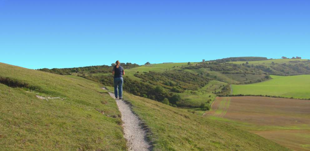
Above: hiking trail in the
Chilterns
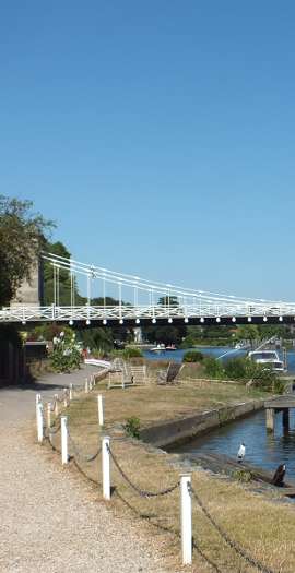
The Thames footpath at Marlow
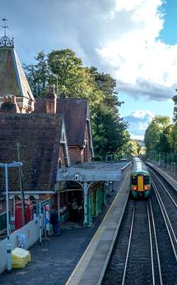
Box Hill station - 50 minutes from Waterloo
Going
to France ?
check out Hiking trails in France
check out Hiking trails in France
Box Hill station photo by Designjeep
Other photos © About-Britain.com